
Severe Flooding in the Pacific Northwest
 Severe Flooding in the Pacific NorthwestTorrential rain in the Pacific Northwest spurred deadly floods and mudslides that have damaged infrastructure and isolated communities in Canada and the United States. Much of the rain fell from November 13-15, 2021, the product of a potent atmospheric river that took aim at the region and added more moisture to already saturated soils.
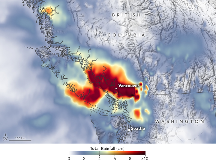
The map above depicts a satellite-based estimate of rainfall over the 24-hour period on November 14—a day that broke numerous records. The darkest reds reflect the highest rainfall amounts, with some places receiving as much as 10 centimeters (4 inches) or more during this period (the top of our scale). The data are remotely sensed estimates that come from the Integrated Multi-Satellite Retrievals for GPM (IMERG), a product of the Global Precipitation Measurement (GPM) satellite mission. Local rainfall amounts can be significantly higher when measured from the ground.
On November 14, the airport gauge in Hope, British Columbia, collected 17.4 centimeters (6.8 inches) of rain. Vancouver measured 5.3 centimeters (2 inches) that day. Both cities set new daily records. The airport in Bellingham, Washington, reported 7 centimeters (2.8 inches), the fifth-wettest day on record. Almost 2 more inches fell the following day, breaking the city’s two-day rainfall record.
The rainstorm was the latest in a parade of storm systems that have walloped the Pacific Northwest in recent months. Parts of the Pacific Northwest have endured an extraordinarily wet autumn, inching toward the seasonal record. With soils already saturated, the torrential rain from the latest atmospheric river posed an even higher risk for flooding and mudslides.
https://www.civilengineering.ai/severe-flooding-in-the-pacific-northwest/


Post a Comment